Weather data for everyone
Radar, warnings, forecasts, observations, outlooks, and other weather data are free and available to every HookScan user.
 Join the beta
A Welcome to the Chase project
Choose TestFlight, Google Play, or a direct APK download.
Installation help & beta details
HookScan brings professional radar, official warnings, forecasts, and intelligent weather guidance into one fast experience—built for everyday people, storm chasers, and meteorologists. All weather data is free.
The HookScan weather promise
Radar products, official warnings, forecasts, observations, outlooks, and weather layers are available to every HookScan user. Weather information helps people protect themselves, their families, and their communities, so it should be easy to reach and easier to understand.
From an everyday forecast to advanced storm analysis, the weather picture is here for everyone.
Why choose HookScan
HookScan is designed to remove the choice between an app that is easy to understand and one powerful enough for serious weather analysis.
Radar, warnings, forecasts, observations, outlooks, and other weather data are free and available to every HookScan user.
Start with plain English or move into deeper analysis without leaving the same weather picture or learning an entirely different app.
HookScan brings current radar, official alerts, forecasts, and environmental context together so users can spend less time searching.
Feedback from everyday users, storm chasers, and weather experts shapes the experience, priorities, and performance of every beta.
Built around the weather
Radar, official alerts, forecasts, observations, and storm context work together, so you can understand what is happening without jumping between several products.
Inspect the newest complete radar scans across reflectivity, velocity, dual-pol products, spectrum width, and more—with smooth playback and precise timestamps.
Follow official alerts around the places that matter to you. Warning colors, polygons, details, and optional sounds make urgent information easy to recognize.
Ask everyday weather questions or dig into storm details. HookScan combines official weather information with plain-language explanations built for real decisions.
Bring radar, lightning, observations, outlooks, hurricane guidance, storm reports, upper-air data, and forecast layers together without jumping between apps.
See the real product
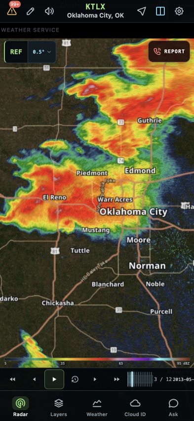
Real NOAA radar from the May 31, 2013 El Reno tornado event, displayed in the current HookScan beta. These are historical research examples; the alert bar reflects current conditions, not warnings from 2013.
Strong radar returns around El Reno and Oklahoma City show the storm in geographic context. Historical KTLX scan · May 31, 2013.
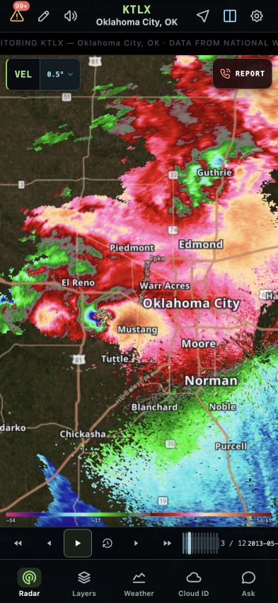
Doppler velocity shows motion toward and away from the radar. Compare it with reflectivity to study the storm. Historical KTLX scan · May 31, 2013.
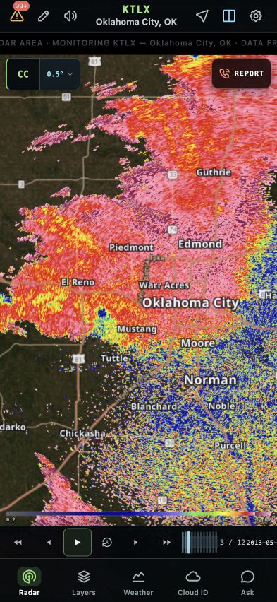
Correlation coefficient adds information about the consistency of radar echoes. Interpret it alongside other products and official information. Historical KTLX scan · May 31, 2013.
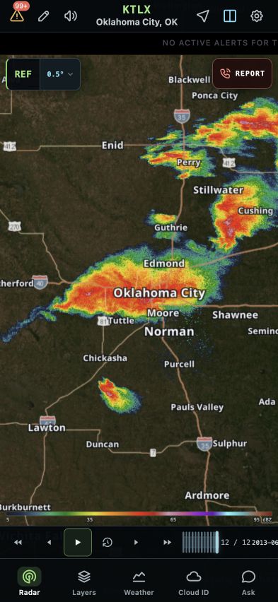
Zoom out to see the surrounding storms and precipitation while retaining radar playback and map context. Historical KTLX scan · June 1, 2013 at 00:14 UTC.
Layers inside HookScan
Everyday Mode explains layers in plain English. Chaser and Professional modes keep the technical product names and deeper analysis tools.
Super-resolution reflectivity, velocity, storm-relative velocity, correlation coefficient, differential reflectivity, specific differential phase, and spectrum width.
Visible, infrared, water-vapor, and snow/ice imagery—plus recent Geostationary Lightning Mapper data for cloud and storm evolution.
NWS warning areas, SPC outlooks and discussions, WPC rainfall guidance, NHC tropical tracks, and official watches and advisories.
National composite reflectivity, precipitation totals, enhanced echo tops, hail guidance, and low- and mid-level rotation products.
HRRR, NDFD, RAP, NAM, GFS, GEFS, RRFS, HREF, NBM, and other guidance for timing, precipitation type, and larger weather patterns.
METAR and mesonet observations, river gauges, local storm reports, soundings, hodographs, and weather-station data.
An app for everyone
No weather background is required. HookScan changes how information is explained while keeping the same dependable weather data underneath.
We understand that radar and weather information can be hard to interpret—especially when conditions are changing fast. HookScan is being built to make weather easier to understand for an everyday person protecting family and friends, while still giving storm chasers, meteorologists, and experts the depth they rely on. Every HookScan user gets access to the weather data at no charge, regardless of experience level.
No weather experience needed
Plain-English explanations, local alerts, easy forecasts, and feature guides help you understand what is happening and what to do next.
Fast, field-ready awareness
Newest complete radar scans, advanced products, dual-screen analysis, storm reports, and rich map layers keep the weather picture close at hand.
Deeper analysis when it matters
Super-resolution and dual-pol radar, upper-air data, hodographs, outlooks, models, and detailed storm context support expert-level analysis.
WEATHER DATA
SHOULD HELP
PEOPLE ACT.
Built by Welcome to the Chase
HookScan was created because weather information is often scattered, overly technical, or locked behind upgrades. During severe weather, people should not have to hunt through several products or already understand meteorology to make a safer decision. We are bringing live radar, official alerts, forecast context, and clear explanations into one connected experience.
One HookScan ecosystem
No matter which device or operating system you use, HookScan is being built to keep the same free weather data within reach—because dependable weather information should be available to everyone.
Cloud ID, severe-weather reporting, location-aware alerts, widgets, and a touch-first radar experience.
The same core weather and radar experience, adapted for modern phones, tablets, foldables, and varied screen sizes.
A desktop workspace for deeper analysis, including computer-only 3D radar rendering and storm cross sections.
Public beta · Free to test
Try the newest HookScan features and help shape what comes next. Choose your platform to get started.
Join our public beta in Apple TestFlight. Install TestFlight first, then accept the invitation to HookScan.
iOS public beta Public beta · Build 41 availableJoin the public test with your Google account, then install HookScan through Google Play.
Android public beta Updates arrive through Google Play.Already a tester? Open store listing ↗For phones without Google Play Services. Uses Android’s native GPS and installs separately as HookScan Beta.
.APK public beta Android 7.0+ · 49.6 MB · Version 1.2.0-beta (41)Installation details & limitations ↓Android public beta is available in the United States. Choose Google Play for automatic updates, or download the APK directly.
Updates: HookScan Beta checks for updates while open. Go to Settings → APK updates, tap Download update, then Install update. Android asks you to approve the installation and may first ask you to allow updates from HookScan Beta. Future updates can be downloaded inside the app without returning to this website. Install over HookScan Beta to keep your settings—do not uninstall it first. Google Play does not update this separate app.
Already using build 40 or earlier? Install this update once from the button above to enable downloads and updates inside HookScan Beta.
Alert limitation: This APK has no Google push service. Weather alerts refresh while HookScan is open; remote alerts while the app is closed are unavailable. Optional Spotter Network location reporting uses a separate, user-started Android foreground service.
Beta limitations: Hosted full-run model loops remain unavailable. Physical de-Googled phone testing is still needed. Keep another reliable source of official warnings available.
Have a bug report or feature idea? In HookScan, open Settings → Beta testing to email feedback with app and device details. You review the email before sending. You can also send beta feedback here or use TestFlight’s feedback tools.
Public weather sources
HookScan does not create official warnings or forecasts. It organizes trusted public weather information, displays it together, and explains it for different experience levels.
 NOAA
NOAA National Weather Service
 National Hurricane Center
 National Severe Storms Laboratory
NEXRAD Level II and III radar, active alerts, point and office forecasts, METAR/ASOS observations, Hazardous Weather Outlooks, and National Water Prediction Service river data.
Storm Prediction Center outlooks, watches, and discussions; Weather Prediction Center rainfall and surface products; Climate Prediction Center outlooks; and National Hurricane Center advisories.
NOAA GOES-19 imagery and GLM lightning, NOAA MRMS products, and NOAA/CIMSS ProbSevere storm guidance distributed through public NOAA data services.
Iowa Environmental Mesonet warning, watch, storm-report, and tile services; NIFC/WFIGS and InciWeb fire information; and Esri basemaps with OpenStreetMap contributor data.
HookScan is grateful to the meteorologists, researchers, engineers, observers, and public-data teams who make modern weather awareness possible—especially NOAA, the National Weather Service, the National Hurricane Center, and the National Severe Storms Laboratory.
HookScan is an independent product and is not endorsed by, affiliated with, or an official service of these agencies or organizations.